Ricochet is the best place on the internet to discuss the issues of the day, either through commenting on posts or writing your own for our active and dynamic community in a fully moderated environment. In addition, the Ricochet Audio Network offers over 50 original podcasts with new episodes released every day.

 The Global Positioning System Is Just a Bunch of Fancy Clocks
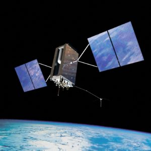
Artist’s rendition of a GPS III-A satellite (U.S. Air Force)
The Global Positioning System provides a simple and invaluable service to any Earthling who chooses to access it. It solves an ancient problem with ultramodern technology, answering a challenge that spelled doom for so many of our ancestors. With some irony it answers the profoundly local and timeless question — “Where am I?” — using atomically synchronized radio transmitters orbiting thousands of miles up in space.
The knowledge of one’s precise location is now so mundane it almost seems strange to ask the question. It’s a problem we no longer think about, taking for granted that knowing where we are is just a matter of looking down at our smartphones. But how does a smartphone know where it is? Some people would be happy with “by using satellites and computers.” I find it hard to phrase the question in such a way that inspires curiosity. But it is actually an interesting and challenging technical problem with an impressive solution.
First I’ll mention a few things GPS does not do. It doesn’t know any addresses, plan routes, or give turn-by-turn directions. And it doesn’t track anybody. Those are all add-on systems that take advantage of GPS positioning technology, an explanation of which follows.
The United States Air Force operates the NAVSTAR Global Positioning System (as it’s officially called), providing a completely free-of-charge, continuous, worldwide, highly accurate position, velocity, and time (PVT) service, simultaneously to any user with a receiver. They even provide something of a user’s manual for GPS developers. It’s light reading at only 226 pages of orbital mechanics, relativity, radio frequency equations, and encoding keys.
It was developed as a military system starting in the 1970s and ’80s, becoming fully operational in the ’90s. A person involved in the original development once told me that when they forecast all the ships, airplanes, tanks, helicopters, and soldiers who would use the system, they estimated there would be a maximum of 40,000 users worldwide. Now there are tens of millions of new civilian GPS receivers manufactured every month and billions of users. While it is a government-developed infrastructure so to speak, this is a testament to the power of the free civilian market to find new, productive, and unimagined ways to exploit resources.
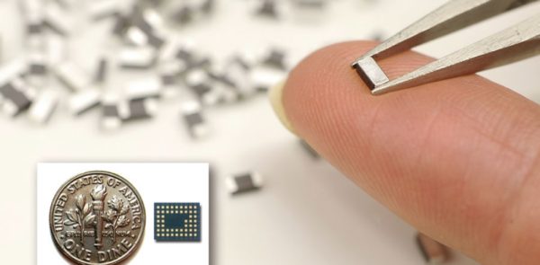
A modern, fully functional GPS receiver. (Photo credit: AIN Online)
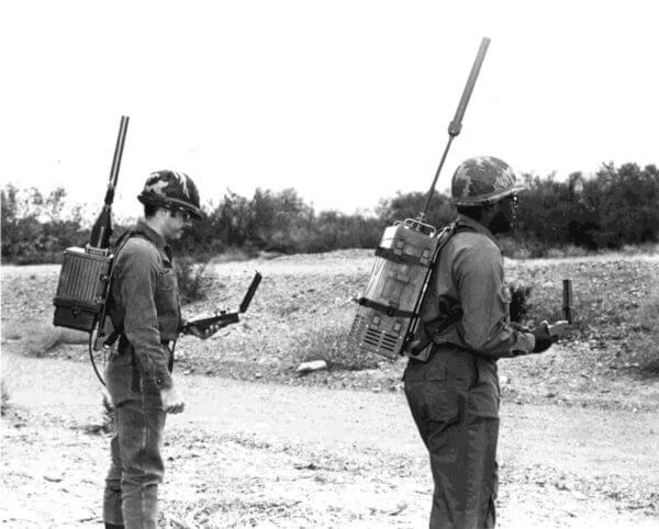
Two soldiers test early models of GPS manpack receivers in 1978. (U.S. Air Force)
The GPS constellation contains about 32 satellites carrying synchronized atomic clocks and radio transmitters. They are distributed around the world in six sets of nearly circular 12-hour orbits at 20,000 km altitude, a little more than half the altitude of geostationary satellites. The satellites travel in their orbits at almost 4 km/s and their paths are angled 55 degrees to the equator. A user anywhere on the globe has a clear view of about 6 to 12 satellites in the sky at any time.
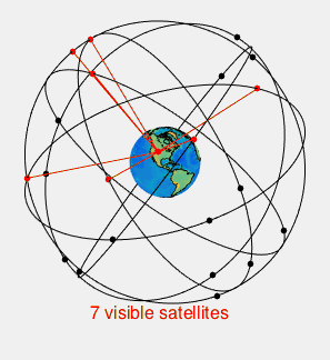
A visualization of a 24 satellite GPS constellation showing which satellites are visible (red) to a user in Colorado. Credit: By Paulsava – Own work, CC BY-SA 4.0, https://commons.wikimedia.org/w/index.php?curid=47210072
Given the thousands of different uses for GPS in commerce, agriculture, transportation, surveying, and scientific research, many people wonder: how do the satellites know where you are, and how can they handle tracking billions of worldwide users?
The answer is they don’t, and they don’t need to.
The GPS satellites are broadcast-only, receiving no data from the users and performing no position calculations onboard. The satellites never know where you are or even that you exist. All position calculations are performed by the receivers, so the number of users is unlimited just like FM radio. The only way somebody can track you using GPS is if your receiver actively rebroadcasts your position.
The data messages broadcast by the satellites contain a lot of detailed information about their operational status and orbital parameters. But this data is also available for free on the internet, which is how most smartphones get it nowadays. So really the only unique information the satellites are broadcasting is the time. Each satellite broadcasts a precise timing signal at precise intervals interspersed with its data messages. All GPS satellites broadcast these timing signals simultaneously using atomic clocks onboard which are maintained in very tight synchronicity by the ground controllers.
When a GPS receiver receives the regularly scheduled timing signal from each satellite, it records the time of receipt based on its own internal clock and subtracts the time it was sent to find the signal travel time. It multiplies the travel time by the speed of light (and compensates for a few second-order effects like relativity and ionospheric refraction) to find its range from each satellite. Then it uses the orbital parameters to calculate the satellite’s position at the precise time that it sent the signal.
Now, knowing where the satellites were and having a range measurement to each, it’s simple for the receiver to calculate the its position using a process called trilateration (not to be confused with triangulation, which uses angle measurements). In simple terms, it is finding the intersection of multiple spheres. Each measurement tells you that you are somewhere on the surface of a sphere centered on one of the satellites. Let’s call these range spheres. You are therefore located at the intersection of the the range spheres.
Intuitively it seems like three satellite range measurements are all you need to calculate your position in three dimensions. But three’s not enough. There is an inherent, common uncertainty in the range measurements, and therefore the sizes of all the spheres. This is because the receipt time provided by the internal clock of your GPS receiver is not accurate. Remember, receipt time is used to calculate the range to each satellite. For a signal traveling at the speed of light, every nanosecond of offset in the receipt time due to receiver clock error is a foot of range error. A millisecond of receiver clock error is a million feet of error in the size of all the spheres! If you only use three satellites, there is no way to get an accurate position calculation with a reasonably affordable clock.
Adding a fourth satellite locks in the receiver clock error. There is only one unique value of receiver time that gives compatible sizes of all four range spheres to place you at a single point of intersection. By using four range measurements, the receiver simultaneously fixes its own clock error and determines your position accurately.
With the full NAVSTAR constellation now operational it’s rarely a problem to find four or more satellites. More than four satellites usually gives a more accurate position by allowing the receiver to partially account for other more subtle errors in the range measurements like the effects humidity in the lower atmosphere.
We have only scratched the surface of GPS here. There is so much that could be written about the brilliant signal encoding that allows all the satellites to broadcast on the same frequency simultaneously, the magic of pulling a very faint signal out of a cacophony of background noise, and the other signals and techniques that can be used to greatly increase the accuracy. Every time I sit and think about it, I am in awe of the system and how it works so intricately and precisely. Calling it “just a bunch of fancy clocks” is not a sleight, but a testament to its elegance. I would not be alone in saying GPS is one of mankind’s greatest technological achievements, right on par with the Apollo moon landings.
Published in Science & Technology
Thanks for a well written post on how GPS really works. It’s tough to write to such a diverse Ricochet background, but I think most can understand it.
Before I moved to Fort Wayne, IN, much of the original technology was developed here by Magnavox, where I worked after it was later purchased by Raytheon.
Years ago I was a space navigator. When I started the Tracking and Data Relay Satellite System (TDRSS) did not yet exist. At the time we had to determine the Shuttle’s state vector (position and velocity at a given time) through data reduction of tracking station observations (including TDRSS tracking) It was labor-intensive requiring three people at the Nav console. So, for 24×7 operations, seven days a week we would need a team of about 24 people (allowing for training and vacations). Expensive. When GPS came along I prepared a paper showing we could cut staffing to about 9 using GPS for Space Station navigation. Wrong answer. Mission Operations Directorate managers measured their manhood by the number of people working for them, not the efficiency and effectiveness of mission support. I was told to withdraw the paper and destroy all copies of it.
Even if management did not see the writing on the wall I did. I got out of near-Earth orbit navigation (viewing it as a solved problem) and moved into rendezvous navigation and deep space navigation. Stuff requiring more than GPS.
Seawriter
Great post. I first started using GPS back in the mid 80’s while in the Navy. We had to anchor the ship just to get a fix. Now I can be speeding down the interstate at 100 MPH and get a vastly more accurate fix. Talk about progress :-).
For boaters, GPS has led to a truly lifesaving system called AIS. AIS receives from and transmits to other ships & satellites digital information about your ship (GPS location, speed, heading, engineering parameters, whatever other data you want to send). It sends data to all your electronic equipment such as chart-plotters, radios, etc. In an emergency, you just press a red DSC button on any of the radios, and it continually broadcasts that info over that VHF or SSB antenna. Those are very high frequency and high frequency transmitters.
I love that any Tom, Dick or Harry can set up a local GPS station, allowing for much more precise augmentation for local signals. This is pretty normal for airports now, and it means that vehicles can be plotted to within an inch or better.
Thanks for the interesting post. Fascinating stuff.
That was an excellent description of GPS. As some of you know, I’ve written a book about it. http://www.gpsdeclassified.com I’m headed to AF Space Command to talk about GPS.
Great post Mark. Thanks.
The OP talks about U.S. satellites and their relation to our smart phones. Where do the other GPS satellites from other countries come in? Don’t Europe and China have similar systems. How do they interact with ours?
The spirit of John Harrison objects to your denigration of “fancy clocks”. Civilization owes much of its existence to “fancy clocks”.
I enjoyed Dava Sobel’s book Longitude about Harrison’s clocks. I have a great deal of respect and sympathy for him, and I hope you read to the last paragraph to see that no sleight was intended.
I was elected to lead, not to read.
Thanks for the very informative post. Great job!
The joke commonly shared at Marine Aerial Navigation School was that never has anyone worked so hard for a dead-end, soon to be obsolete job. Sure enough, we were right, they are no more.
GPS technology is amazing, near sorcery.
Very, very cool. Thanks.
They are at different orbital altitudes. The GPS satellites have 11h 58m orbital periods, which is half a sidereal day. Twice each sidereal day they same satellites show up in the same place in the sky.
The other countries have chosen different orbital periods so their satellites are at different altitudes. The Russians use 8/17 of a sidereal day, the Europeans use 10/17 of a sidereal day, and the Chinese use 7/16 of a sidereal day. These result in different repeating behavior.
GPS is a great technical acheivement. But we have become so dependent on it, that if it goes down there will be lots of disruptions.
Yes, always good to keep that in mind. Also true for electricity, telephones, and the internet.
For that reason, some military systems I have come in contact with are required to meet their navigation requirements in a GPS-denied environment. They are allowed to use GPS to augment performance but they must not be dependent on it.
Very nice article. I’ve always understood the system to be orbiting clocks, but it’s nice to get a little more detail.
Yeah, now. When I was working on my first system that utilized a GPS, we had to run a program to check to see when we would have enough visible satellites for a flight test. One of our managers walked up as two of us were discussing whether we’d have a constellation suitable for testing the next day and walked away muttering that next we’d be putting in purchase requests for bats’ wings and newts’ eyes.
And I bet the orbits were uphill both ways! And you had to do a cold start and download the almanac over the air, through three feet of snow! And the ephemeris was printed on paper and weighed 50 lbs and had to be borrowed from the library and carried on your back to the test site!
See, I was thinking about this and using the Galilean Moons to fix longitude. Navigation really is all about checking your watch.
I use gps the way we all have become dependent on it, such that we fail to remember how truly unlikely and awesome it is. We don’t have hovercars, but we do have Dick Tracy wristwatches and gps.
I am an avid geocacher, which gps makes possible. I have to laugh at myself when my little hand-held phone directs me to a random spot in the wilderness, and I am irritated if it is off by 10 feet. Is this a great country or what?
Does the app you’re using report the PDOP, number of satellites, and estimated horizontal position error?
@markwilson I spoke at Air Force Space Command last Thursday. I will give post more pictures when I receive them along with the video.
@richardeaston What was the topic?
@markwilson The title of our talk was “GPS: Military Asset, Public Utility”. The commander of AF Space Command, Gen Hyten, introduced it.
https://www.facebook.com/AirForceSpaceCommand/photos/a.423828302073.203448.78118717073/10154452417452074/?type=3&theater
I expect you’re going to reproduce the derivation of that matrix equation for us in an upcoming Ricochet post!
Forty years ago I might have been able to do it.