Ricochet is the best place on the internet to discuss the issues of the day, either through commenting on posts or writing your own for our active and dynamic community in a fully moderated environment. In addition, the Ricochet Audio Network offers over 50 original podcasts with new episodes released every day.
 The 2014 Election Map Is Worth A Hundred Words
Granted, this beauty is worth a whole lot more. Let’s just pause and take it in for a moment, shall we?
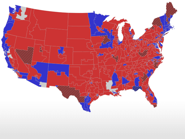
Now, in a hundred words or less, what does this map tell you (and the GOP) about America today and in 2016?
Feel free to pontificate about the country at large, and give advice about how we keep your neck of the woods red, turn it red, or make it even redder.
(This is the RCP election results map for the House as of 11/7.)
Published in General

I think you’ll get hit with this map:
Half the nation’s population lives in those blue blotches. I know, I’m a buzzkill.
The founders were wise when they created the electoral college. Turns out that farmer in SE Nebraska does get a say
It tells me that we desperately need to find a way to take the cultural microphone away from the people who live in those blotches.
It tells me that we desperately need to find a way to connect what we’re selling to what people in urban areas are seeking to buy.
Yes, and the other half of the nation’s population lives on the red carpet. And the point is?
The point is we count votes based on people, not land mass.
Yeah, thanks a lot King P. At least let me finish my coffee. I agree with Ed G.’s comment below. We have to focus on the big cities/population centers and find the right candidates to win there.
And a good chunk of those blue blotches (35-50%) are represented by Republicans according to the map on the top. So, it looks like Republicans have most of great gray swath and a third to one-half of the other half of the population.
I must be slow. Why is that a buzzkill?
Seawriter
What you want to see are rings of red around the big cities. The suburbs, full of hard-working, home-owning, child-raising, two-parent families.
The map tells me that I live in the wrong place.
Me too Merina. I’m in Crazy New England. Ironic that the birthplace of the Revolution is now full of modern monarchists.
That won’t cut it. Not in the long term, anyway. Sooner or later it’ll wind up like Detroit: lavish opulence on one block and inner city crapulence on the next without any middle ground. The suburbs can only remain viable if the cities they feed on remain viable too.
Yes. I’m in Chicago, formerly the world’s leading producer of about a hundred and fifty things. Formerly the place where things got done, where people were on the march and making things. Now it’s the place where people try to get a piece of the shrinking pie before it’s all gone as they’re on their way out the door to Texas and Florida. It’s a poorly curated museum now; the energy which once characterized us is long gone and spurned, now that the fiefdoms are all securely accounted for and accepted by the populace.
Both maps say something important. The political divide in America is mostly a rural vs urban one. I live in Montana which is the most populous Congressional district(Pop. ~ 1 million) and the second largest (after Alaska) Congressional district.
According to CNN:
http://www.cnn.com/election/2014/results/race/house#exit-polls
Why do people have to keep putting up maps that make me embarrassed to be a Minnesotan?
We win flyover country every time. All the great Presidential sweeps of the 20th century by the Republican Party, of which there were many, happened when the Republicans had a 50 state strategy. We can’t just give up on New York and California every time and expect to govern the country without 20% of it.
We gave up on the cities. It’s time to get back in there.
The funny thing is, the Democrats started out as the party of rural farmers, while the Republicans started out as the party of urban industrialists, if I understand it correctly. I guess that’s flipped over time.
Yeah, instead of “what’s wrong with Kansas” how about a few “what’s wrong with minnesota” threads?
Minnesota seems to really defy the national demographic trends.
The rural districts vote Democrat. It’s 87% white. It’s 81% Christian. The average age skews older than the country as a whole. 91% have a high school education or better. It ranks second in the nation with 72% of the population in the labour force. It’s #1 in the country with owner-occupied home ownership. More than half of Minnesotans over the age of 15 are married. Etc. Etc. Etc.
In other parts of the country, these constituencies all favoured Republicans significantly: http://www.cnn.com/election/2014/results/race/house#exit-polls
What makes Minnesota the outlier?
This is why I believe we need a “Win Back The Crack” strategy. The Crack being the Mississippi River. Just calling it what is. Talk of improving the economy will resonate there. Not so much on the coasts.
I believe there is a correlation with the timing of the flip and the degree to which urban industry became globalized.
In ye olden days, agriculture supported free trade because it wanted to sell its produce in Europe, where food prices were higher. Urban industry favoured protectionism because Europe could produce manufactured goods more cheaply.
When urban industry switched its focus to marketing and branding (outsourcing the manufacturing to the far east and latin america), it began to favour free trade more. At the same time, agriculture began to favour protectionism as food imports become cheaper.
“But Misthios,” I hear you crying, “aren’t Republicans the party of free trade?”
I reply to your cry that it’s debatable. NAFTA was signed under Clinton, Bush fils created steel tarriffs, neither party supports ending farm subsidies, and I’m not aware of any obviously protectionist moves made by the Obama administration (other than dragging their feet on Keystone XL, but that’s kind of a special case).
Also, look at where the US’ busiest container ports are located. They’re all in solid Democratic Party strongholds. Shipping is one of the few healthy industries for unionized blue collar workers, thanks to trade.
Randy, as a resident of Minnesota, I feel your pain. Though, I now live in one of those tiny little bastions of red.
I blame some of Minnesota’s crazy dedication to voting Dem on the deeply ingrained political heritage of their ‘progressive’ Scandinavian ancestors, and the “F” in the DFL polluting most, but not all, of the rural folks.
I’ve heard this argument before, and I think it makes sense at the state level, because people are more likely to vote for collective social programs when the electorate is more ethnically and culturally homogeneous.
But the theory makes way less sense at the federal level, where a vote for the Dems means a vote for sending your tax dollars to other jurisdictions, where your Scandinavian brethren don’t live.
(Minnesotans are net contributors to federal coffers. In fact, they get back from the federal government the least of any US state. Who continues to vote for representatives and Senators who DON’T bring home the bacon?!)
This is precisely why the Scandinavian countries were late joining the EU., and why Norway is still a holdout. They don’t want their money going to the rest of Europe.
Given Minnesotans’ relatively high education levels, it seems unlikely that they simply don’t understand the difference between state politics and federal politics, doesn’t it?
(As for the argument that they’re simply too used to the DFL, I cannot comment, since I’m not a Minnesotan, and that’s way too “inside baseball” for me.)
Merina Smith:
The map tells me that I live in the wrong place.
It is odd to disagree with 99% of the people around you, isn’t it? Hence our interest in ricochet, I suppose.
I was just about to say… if only geography mattered more. In the Pacific NW, the map shows mostly red, but Washington is a borderline socialist state, and I don’t see that changing any time soon.
Houston is a Democratic Party stronghold? News to me. Harris County voted Republican this cycle. (Thank you Annise Parker.) There is are Democrat parts of Houston, but those are not near the port area.
The three largest ports in the United States are (in order) Southern Louisiana (the stretch of the Mississippi between New Orleans and Baton Rouge), Houston, and New York-New Jersey. The next eight do not do as much traffic as those three combined.
Beaumont, Texas City, and Corpus Christi do as much traffic combined as Houston by itself.
Of the top fifteen ports in the United States only three or four are in blue states (New York-New Jersey, Long Beach, and Los Angeles with maybe Baltimore on a good year).
The top two ports (Houston and Southern Louisiana) have non-union terminals as well as unionized terminals. Both Louisiana and Texas are right-to-work states.
Southern Louisiana sprung up pretty much to avoid Democrat strongholds like New Orleans.
Houston is the busiest container port with Southern Louisiana a close second. Houston was where containerization was born, and that because it was not unionized.
Seawriter
According to the 2012 Statistical Abstract of the United States the busiest US container ports are
1. Los Angeles
2. Long Beach
3. New York/New Jersey
4. Savannah
5. Oakland
6. Norfolk
7. Houston
8. Seattle
9. Tacoma
10. Charleston
Source: http://listosaur.com/miscellaneous/top-10-busiest-ports-in-the-united-states/
According to the 2010 Census, half of Washington’s population is in Seattle-Tacoma.
The map tells me that if the area up to 100 miles from the Pacific coast or just all of New England to secede, there would be a perpetual conservative majority in the US. Why is the Left Coast so liberal? Silicon Valley is there, etc, but there is little support for business interests?
When I look at a county map of the United States, one thing I see is that the counties in California are unusually large.
Considering that California is such a high-population state, wouldn’t it make way more sense for it to have more, but geographically-smaller, counties than other states?
The larger the county, the more culturally heterogeneous the population is going to be, and that contributes to liberal politics.
For example:
That’s an interesting point Mist. Why does a diverse county create liberalism? I am not disagreeing, but curious. One could perhaps drill down and say that towns or cities should be smaller. New England is the area of small town government and in places no or minimal county government, and yet it doesn’t seem to radiate conservatism.
What is it about a very small area of California, Oregon, and Washington that sends 6 liberal Senators to Washington and perhaps 40 Representatives net? The county size may make a difference, but there has to be some other reason.